🌊 Nepal–Tibet Border Flash Flood Disaster: Real-Time Crisis Overview
A massive flash-flood emergency is actively unfolding along the high-altitude Nepal–Tibet border, devastating communities across the Lhende Khola and Bhote Koshi river basins.
The disaster began following a colossal glacier and ice-rock collapse in the high Himalayas, releasing millions of cubic meters of water, crushed ice, and rocky debris downstream into Nepal's Sindhupalchok and Rasuwa districts as well as adjacent border settlements in Tibet.
Rescue operations are underway in hazardous conditions, with continuous rain, severed highway connections, and compromised communication lines slowing recovery efforts.
🗺️ Himalayan Flash Flood River Flow Map: Origin to Downstream Impact Corridor
Understanding the geographic trajectory of the flood surge is crucial for search-and-rescue teams, downstream residents, and emergency coordinators. The flood follows a high-velocity descent across seven critical checkpoints from the Tibetan high plateau down to the Indo-Gangetic plains:
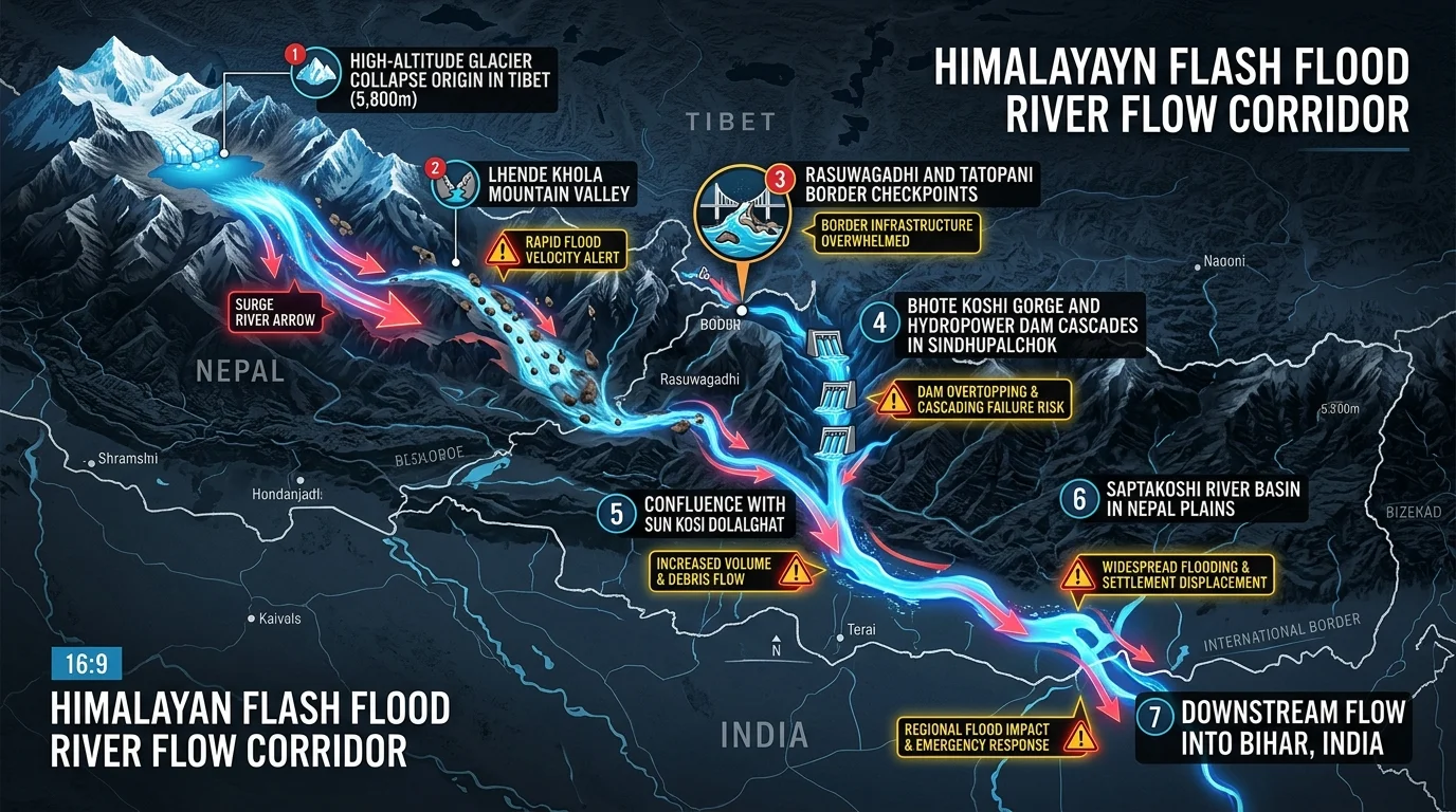
📍 River Flow Path & Key Critical Checkpoints:
1. Checkpoint 1: High-Altitude Glacier Collapse Origin (Tibet, 5,800m+) Location & Terrain:* Steep glacial cirque and moraine-dammed lake in the Tibetan Himalayas. Impact:* Catastrophic ice-rock avalanche triggers massive displacement wave, breaching the moraine dam and releasing millions of cubic meters of water and rocky slurry.
2. Checkpoint 2: Lhende Khola Mountain Valley Location & Terrain:* High-gradient canyon funneling water from Tibet toward the Nepal border. Impact:* High kinetic flood velocity carries multi-ton boulders; early warning acoustic sensors trigger rapid velocity alerts.
3. Checkpoint 3: Rasuwagadhi & Tatopani Border Checkpoints Location & Terrain:* International border customs crossings and Araniko Highway corridor. Impact:* Border immigration facilities overwhelmed, bridge piers sheared off, and highway links severed, stranding trade convoys and Kailash pilgrims.
4. Checkpoint 4: Bhote Koshi Gorge & Hydropower Dam Cascades (Sindhupalchok) Location & Terrain:* Narrow, steep gorge lined with run-of-the-river hydroelectric power plants. Impact:* Hydro dam gates overtopped by debris flows; transmission lines snapped, triggering localized power grid blackout and trapping infrastructure crews.
5. Checkpoint 5: Confluence with Sun Koshi at Dolalghat Location & Terrain:* Major river junction where Bhote Koshi merges into the wider Sun Koshi river. Impact:* Flood volume doubles with heavy sediment and debris accumulation; secondary evacuation sirens sound in Kavrepalanchok.
6. Checkpoint 6: Saptakoshi River Basin (Nepal Plains / Terai) Location & Terrain:* Broad alluvial floodplains of eastern Nepal. Impact:* Floodwaters spread across riverbanks; widespread agricultural inundation and low-lying village evacuations across Sunsari, Saptari, and Morang.
7. Checkpoint 7: Downstream Inflow into Bihar, India Location & Terrain:* Koshi river embankment network entering northern Bihar (Supaul, Saharsa, Madhepura). Impact:* India's Central Water Commission (CWC) issues high flood alerts; embankment monitoring teams placed on 24/7 vigil to prevent breaches.
📊 Casualties, Missing Persons, and Ground Situation (Active Emergency)
Because this is a rapidly evolving disaster, emergency authorities note that casualty and missing-person figures are subject to rapid upward revision:
- Nepal Fatalities: Nepal Police and Armed Police Force (APF) have confirmed at least 547 deaths across riverbank settlements, road transit corridors, and hydropower project sites in Sindhupalchok, Rasuwa, and surrounding valleys.
- Tibet Fatalities: Chinese provincial emergency authorities have reported 5 confirmed deaths in border administrative zones.
- Missing in Nepal: Approximately 977 people remain unaccounted for, including dozens of workers at riverbed infrastructure sites and international travelers.
- Missing in Tibet: At least 558 people are currently listed as missing, with high-altitude transit camps cut off by mudslides.
- Infrastructure Collapse: Key bridges along the Araniko Highway, international customs checkposts at Tatopani and Rasuwagadhi, power transmission towers, and several operational run-of-the-river hydropower facilities have sustained catastrophic structural damage.
- Secondary Threat (Landslide Dam): An unstable landslide-dammed lake formed near the border has begun overflowing, triggering emergency siren alerts and prompt downstream evacuations across Sindhupalchok and Kavrepalanchok districts.
🔍 Point A: Is the Disaster Natural, Man-Made, or a Lethal Convergence?
One of the central debates surrounding high-altitude Himalayan flash floods is whether these catastrophes are purely natural acts of nature or the direct byproduct of human activity. Geological evidence indicates that this disaster is a lethal convergence of natural triggers amplified by anthropogenic factors:
1. The Natural Geological Triggers
- High-Altitude Glacier & Rock Avalanche: The initial surge was initiated when a massive hanging glacier destabilized and sheared off a steep cirque wall at an elevation exceeding 5,800 meters, crashing into a moraine-dammed glacial lake.
- Glacial Lake Outburst Flood (GLOF): The sudden dynamic impact created displacement waves that breached the fragile terminal moraine, releasing an explosive hydraulic pulse (GLOF) carrying boulders and glacial slurry down the narrow Bhote Koshi canyon.
- Fragile Seismic Landscape: The central Himalayan belt is young, tectonically active, and fractured from the 2015 Gorkha earthquake and subsequent seismic tremors, leaving mountainsides susceptible to catastrophic mass wasting.
2. The Anthropogenic (Man-Made) Amplifiers
- Accelerated Cryosphere Melting from Global Warming: Human-driven greenhouse gas emissions have caused the Hindu Kush Himalayan (HKH) region—the "Third Pole"—to warm at nearly three times the global average rate, dramatically accelerating glacial retreat and swelling precarious high-altitude lakes.
- Unplanned Riverbed Encroachment & Road Blasting: Unregulated excavation of hillside highways (such as unengineered slope cutting for mountain corridors) without proper slope stabilization has destabilized valley walls, generating massive debris loads during heavy runoff.
- Hydropower Dam Density in Fragile Valleys: The concentration of cascading hydroelectric barrages along the Bhote Koshi and Trishuli basins creates artificial choking points. When reservoir gates fail to open in time or are overwhelmed by boulder-choked debris flows, structural overtopping exacerbates downstream surge heights.
| Factor Category | Primary Drivers | Contribution to Catastrophe |
|---|---|---|
| Natural Trigger | Hanging glacier collapse, moraine breach (GLOF), extreme high-altitude cloudburst | Generated the initial multi-million cubic meter hydraulic wave pulse. |
| Geological Fragility | Steep gradient canyon geometry, seismic fault fracturing, high silt erosion | Accelerated kinetic velocity and multiplied mud-and-rock debris volume. |
| Anthropogenic Driver | Climate-induced glacial thinning, unscientific road blasting, valley encroachment | Increased vulnerability of settlements and magnified flood impact tenfold. |
⚡ Point B: What Happens If China's Biggest Dam or Major Upstream Dams Are Damaged?
The Himalayan river networks form the lifeline of South and East Asia. The prospect of catastrophic damage or structural failure at major upstream mega-dams in China—such as the projected 60 GW Yarlung Tsangpo Megaproject on the Great Bend of Tibet or the Three Gorges Dam in central China—represents a scenario of unprecedented regional consequence.
1. Hydrodynamic Flood Pulse & Downstream Inundation
If a major Tibetan transboundary cascade dam or massive reservoir were to suffer a catastrophic breach due to extreme seismic rupture, massive landslides, or GLOF overtopping: Catastrophic Wave Propagation:* An explosive multi-billion cubic meter surge would funnel through deep Himalayan gorges within hours. Devastation in India (Arunachal Pradesh & Assam):* The flood wave entering India via the Siang/Brahmaputra gorge would submerge hundreds of kilometers of riverbank within 3 to 6 hours, inundating cities like Pasighat, Dibrugarh, Tezpur, and Guwahati under 10 to 20 meters of fast-moving sediment-heavy water. Widespread Submersion in Bangladesh:* As the surge exits into the low-lying delta, millions of hectares of agricultural land in northern and central Bangladesh would be inundated, displacing an estimated 25 to 40 million people. Impact in the Koshi & Ganges Basin: A breach on rivers feeding into the Koshi system (like the Bhote Koshi / Sun Koshi) would devastate eastern Nepal's plains and unleash massive embankment breaches across northern Bihar and eastern Uttar Pradesh*, destroying critical rail, highway, and agricultural infrastructure.
2. Massive Silt Deposition & River Course Deviation
Himalayan flood surges carry millions of tons of coarse sand, quartz gravel, and boulders. A catastrophic dam failure would deposit meters of infertile silt over fertile river valleys, sterilizing agricultural breadbaskets for decades and forcing major rivers to permanently avulse (carve new channels), wiping out towns situated miles away from current riverbanks.
3. Regional Power Grid Collapse & Industrial Paralysis
Major upstream dams generate immense blocks of baseline hydroelectricity. A structural collapse would instantly trip regional high-voltage transmission grids, knocking out gigawatts of power, crippling industrial production, communication networks, and electrified rail transit across neighboring provinces and downstream regions.
4. Transboundary Geopolitical Emergency
Because international water-sharing treaties in the Himalayan basin remain limited, a dam failure without real-time early warning data sharing would trigger severe geopolitical friction between China, Nepal, India, and Bangladesh, highlighting the urgent need for automated multilateral hydrological data exchange protocols.
🛡️ Point C: Comprehensive Safety Precautions & Life-Saving Protocols
When flash floods, GLOFs, or dam-breach waves strike mountain valleys, response times are measured in minutes. Implementing precise safety precautions is the difference between survival and tragedy:
1. Immediate Action During a Mountain Flash Flood Alert
- Seek Immediate High Ground (Vertical Evacuation): Move immediately to higher hillside slopes—at least 30 to 50 meters above the valley floor. Never attempt to outrun a flash flood horizontally along the riverbed road.
- Avoid Bridges and Concrete Embankments: Mountain floodwaters carry massive tree trunks and multi-ton boulders that exert immense hydrostatic force, capable of shearing bridge piers and collapsing retaining walls in seconds.
- Abandon Vehicles Immediately: Never attempt to drive through flooded roads or low-lying bridges. Flood currents moving at just 30 cm depth can sweep away SUVs and heavy trucks.
- Stay Clear of Riverbed Canyons: Even if the weather is sunny in your immediate valley, high-altitude cloudbursts and glacier collapses can send a sudden wall of water rushing downstream without local rain warning.
2. Pre-Disaster Community Preparedness & Early Warning
- AI & Satellite GLOF Monitoring: Deploy automated Synthetic Aperture Radar (SAR) and high-frequency acoustic river level gauges that trigger localized siren towers when river water levels surge or drop abnormally (an abrupt drop indicates a temporary landslide dam that will soon burst).
- Demarcate Red-Zone Hazard Areas: Municipalities must enforce strict no-construction buffer zones within 200 meters of high-risk mountain torrents.
- Establish Community Evacuation Routes: Every mountain settlement and trekking post must have marked, lit uphill escape paths leading to fortified evacuation shelters.
3. Emergency Kit & Survival Checklist for Travelers and Locals
- 1Emergency Beacon & Whistle: High-decibel whistle, satellite SOS communicator (e.g., Garmin inReach), and waterproof LED flashlight.
- 2Water Purification: Portable gravity water filters and chlorine dioxide tablets to treat flood-contaminated water supplies.
- 3Thermal Protection: Compact foil space blankets and waterproof jackets to prevent hypothermia in cold high-altitude conditions.
- 4Offline Maps & Power Banks: Pre-downloaded topographic offline maps (OSM/satellite) and rugged solar power banks.
- 5Emergency Cash & Waterproof ID Pouch: Physical currency and copies of passports/permits sealed in watertight bags.
🌍 Point D: Missing Persons Demographics — Which Countries Are Affected?
The Nepal–Tibet border region is a globally renowned trade, trekking, and pilgrimage artery. The sudden timing of the flood caught multiple demographic groups completely unprepared:
| Demographic / Origin | Est. Missing | Primary Locations |
|---|---|---|
| Indian Nationals | 450+ | Kailash Pilgrims, Rasuwa Road |
| Nepali Citizens | 520+ | Hydro Workers, Guides, Locals |
| Chinese / Tibet Region | 558+ | Border Customs, Highway Camps |
| International Trekkers | 50+ | Langtang & Manaslu Circuits |
1. Indian Nationals & Mount Kailash Pilgrims
- Kailash–Mansarovar Yatra Transit: Hundreds of Indian pilgrims were in transit along the Kathmandu–Syabrubesi–Rasuwagadhi–Kerung border corridor heading toward Mount Kailash and Lake Mansarovar in Tibet.
- Stranded Convoys: Several passenger bus convoys and SUV groups were caught in mudslides between Timure and Rasuwagadhi. Indian consular teams are working closely with Nepal's Ministry of Foreign Affairs to establish transit shelters and heli-evacuate stranded elderly pilgrims.
2. Local Nepali Citizens & Hydropower Personnel
- Hydroelectric Project Workers: Substantial missing numbers comprise civil engineers, heavy equipment operators, and laborers stationed at run-of-the-river dam sites along the Bhote Koshi.
- Local Mountain Communities & Porters: Villagers in low-lying riverside hamlets in Sindhupalchok, along with local Sherpa guides and trekking support crews, were caught in the dead of night when the primary water surge struck.
3. Chinese Citizens & Tibetan Border Personnel
- Highway Maintenance & Customs Staff: On the Tibetan side of the border, road maintenance crews, transport logistics drivers, and border immigration personnel in the Gyirong/Kerung port sector account for the majority of the 558 unaccounted individuals.
4. International Trekkers (Europe, North America, East Asia)
- Foreign mountaineering and trekking teams traversing the Langtang Valley, Helambu trail, and high-altitude passes near the Tibetan frontier were reported out of contact due to collapsed cellular towers and satellite relay disruption.
📞 Emergency Consular Helplines & Rescue Coordination Contacts
If you have family members or relatives traveling along the Nepal–Tibet border, use the following verified emergency contact desks:
- Embassy of India, Kathmandu Crisis Control Room: +977-1-4412143 / +977-9851107021
- Nepal Disaster Management Division (MOHA Control Desk): 1149 (Toll-Free within Nepal) / +977-1-4200054
- Nepal Red Cross Society Search & Rescue Desk: +977-1-4270650
- Armed Police Force (APF) Nepal Flood Relief Hotline: 1114
- China/Tibet Emergency Foreign Affairs Desk (Gyirong Port): +86-892-8282110
⚡ Key Takeaways for Travelers and Authorities
Summary: The catastrophic August 28, 2026 Nepal–Tibet border flash flood underscores the extreme vulnerability of Himalayan river valleys to climate-accelerated cryosphere collapse. As rescue teams navigate severed roads and unstable landslide-dammed lakes, the international community must prioritize transboundary early warning infrastructure, strict riverbed zoning, and coordinated cross-border disaster response mechanisms to protect human lives in the fragile Himalayas.
Nepal–Tibet Flash Flood: Casualty & Crisis Matrix
Live emergency statistics, causality index breakdown, transboundary dam breach risk model, and country-wise missing demographics.
Sindhupalchok, Rasuwa, and Bhote Koshi settlements.
Including Indian pilgrims, hydro crews, and villagers.
Gyirong/Kerung border and high-altitude highway camps.
Landslide-dammed lake breach warning issued downstream.
Real-time elevation drop, terrain dynamics, and infrastructure impact across 7 key river checkpoints.
Ice-rock avalanche ruptures moraine lake, discharging millions of m³ of water and debris.
Flood surge accelerates through steep canyon carrying multi-ton boulders and glacial slurry.
Immigration checkpoints destroyed, bridge piers sheared off; Kailash pilgrims stranded.
Run-of-the-river dams choked with silt; power lines severed, localized grid blackout.
Bhote Koshi merges with Sun Koshi; secondary downstream evacuation sirens activated.
River widens across alluvial floodplains; low-lying agricultural zones submerged.
High flood warnings issued; India Central Water Commission monitors Koshi barrage embankments.
Landslide-dammed lake breach could unleash secondary wave; downstream rescue teams on high alert.
Relative contribution of natural geomorphological processes versus anthropogenic climate and development factors.
Scenario Model: Downstream Consequences of Major Upstream Dam Failure in Tibet / China
Hydrodynamic simulation projections if major transboundary storage dams or glacial cascades suffer structural collapse.
A massive surge would hit Arunachal Pradesh & Assam in 3–6 hours, inundating Brahmaputra floodplains under 10–20m of water and displacing 25M+ people in Bangladesh.
Millions of tons of coarse quartz silt would bury agricultural lands across the Koshi & Ganges plains, sterilizing fertile farmland and altering river courses permanently.
Instant loss of multi-gigawatt baseline hydropower would collapse regional grids, triggering cross-border diplomatic disputes over transboundary hydrological data sharing.
Missing Persons Demographic Distribution by Country of Origin
Stranded in Rasuwa, Timure, and high-altitude border lodges.
Dam site workers, mountain guides, porters, and riverside families.
Highway maintenance teams and Gyirong port customs staff.
Langtang and Manaslu expeditions out of contact.