🌋 Breaking Emergency: Mount Anak Krakatau Enters Violent Eruptive Phase
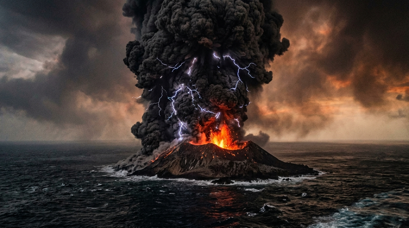
Indonesian authorities, volcanologists, and national civil aviation coordinators are actively managing a rapidly unfolding crisis across the Sunda Strait as Mount Anak Krakatau (Child of Krakatoa) unleashes a barrage of high-intensity explosive eruptions.
The volcano—situated in the narrow maritime passage separating Java and Sumatra—has propelled towering plumes of volcanic ash, pulverized rock, and sulfurous gases to altitudes exceeding 3,000 meters (nearly 10,000 feet) above sea level, triggering urgent regional airport groundings, international flight route rerouting, and maritime transit slowdowns.
The Center for Volcanology and Geological Hazard Mitigation (PVMBG / Pusat Vulkanologi dan Mitigasi Bencana Geologi) has confirmed that Anak Krakatau remains at Level III (Siaga / Standby Alert)—the second-highest alert level in Indonesia's four-tiered volcanic classification system.
🖼️ Anak Krakatau Eruption in the Sunda Strait
✈️ Aviation Chaos: Why Volcanic Ash Shuts Down Airspace and Engines
The primary driver of regional economic and transportation disruption is the grave danger that airborne volcanic particles pose to commercial and cargo aviation. The Volcanic Ash Advisory Center (VAAC) in Darwin, Australia, alongside AirNav Indonesia, has issued urgent VONA (Volcano Observatory Notice for Aviation) bulletins colored ORANGE to RED.
The Lethal Physics of Volcanic Ash in Jet Turbines
Unlike soft wood ash or domestic smoke, volcanic ash is composed of microscopic, razor-sharp shards of silicate glass, basaltic rock, and crystal fragments with high melting temperatures:
- Turbine Melting Hazard: Commercial turbofan engines operate at combustion temperatures between 1,400°C and 1,700°C. Silicate volcanic ash melts at approximately 1,100°C. When aircraft fly through an ash plume, fine glass particles melt instantly inside the burner, coating turbine blades in molten glass glaze that hardens upon cooling, choking airflow and causing catastrophic multi-engine flameouts.
- Sensor & Avionics Paralysis: Pitot-static tubes responsible for reading airspeed and altitude become clogged in seconds, presenting flight crews with erroneous, conflicting flight instrumentation data.
- Windshield Abrasion & Electrical Arcing: High-velocity volcanic sandblasting strips cockpit windscreens opaque, blinding pilots during approach, while intense static charges generate glowing St. Elmo's Fire across the airframe.
Historical Precedent: Global aviation authorities enforce zero-tolerance protocols following the 1982 British Airways Flight 9 incident, where a Boeing 747 lost all four engines after inadvertently entering an ash cloud from Indonesia's Mount Galunggung before gliding and executing an emergency restart.
🗺️ Airport Closures and Flight Diversion Matrix
AirNav Indonesia and the Directorate General of Civil Aviation (DJPU) have activated emergency contingency flight corridors. Multiple airports have faced temporary halts or substantial schedule adjustments to allow runway inspections and ensure safe separation from moving ash vectors.
| Airport Name & Code | Geographical Location | Current Operational Status | Key Affected Flight Routes | Safety Protocols & Directives |
|---|---|---|---|---|
| 🛫 Radin Inten II (TKG) | Bandar Lampung, South Sumatra | Temporarily Suspended | Jakarta (CGK/HLP), Palembang, Batam | Continuous runway sweep testing for ash deposits; apron grounding of regional turboprops. |
| 🛬 Soekarno-Hatta (CGK) | Tangerang / Greater Jakarta | Open with Major Diversions | Sumatra routes, Singapore, Kuala Lumpur | Flights to northern & western destinations rerouted east before climbing over Java Sea. |
| 🛫 Halim Perdanakusuma (HLP) | East Jakarta, Java | Selective Delays & Holds | Lampung, Bengkulu, Jambi | Departure holds pending shifting upper-level wind vector updates from BMKG. |
| 🛬 Sultan Mahmud Badaruddin II (PLM) | Palembang, South Sumatra | Operational / High Alert | Jakarta, Bandung, Surabaya | Inbound approaches adjusted to avoid southern Sunda Strait air corridors. |
| 🛫 Raja Haji Fisabilillah (TNJ) | Tanjung Pinang, Riau Islands | Open / Transit Watch | Inter-island feeder connections | Monitoring Darwin VAAC drift trajectory toward the Singapore Strait. |
⚠️ 5-Kilometer Danger Exclusion Zone Enforced
The National Disaster Management Agency (BNPB) and local maritime police have established a strict 5-kilometer (3.1-mile) exclusion zone encircling Mount Anak Krakatau's active vent:
- 1Complete Maritime Ban: Fishermen, tourist speedboats, and inter-island charters are legally barred from entering the waters surrounding the island caldera.
- 2Incandescent Rock Bombardment: PVMBG observation posts in Pasauran (Banten) and Kalianda (Lampung) reported ballistic incandescent lava bombs and glowing lapilli rock fragments ejected hundreds of meters into the surrounding sea.
- 3Poisonous Gas Concentrations: Volcanic vents are releasing hazardous concentrations of sulfur dioxide (SO2), carbon dioxide (CO2), and hydrogen sulfide (H2S) capable of causing rapid asphyxiation over open waters.
🌊 Tsunami Early-Warning Systems: Remembering 2018
The current eruptive sequence has placed coastal communities in Banten and Lampung on heightened psychological alert due to the tragic history of the December 22, 2018 disaster.
During that event, an explosive eruption caused a 64-hectare flank collapse of Anak Krakatau to slide violently into the sea, displacing massive volumes of water that generated a catastrophic tsunami without any preceding tectonic earthquake tremor, claiming over 430 lives.
Upgraded Safety Infrastructure in 2026
Indonesian authorities have vastly modernized their maritime tsunami early-warning network to prevent a repeat of 2018: High-Frequency Coastal Radar (HF Radar):* Continuously scans ocean surface currents and detects abnormal sea displacement waves within minutes of a marine landslide. Automated Tide Gauge Network:* Stations placed along Merak, Ciwandan, Sebesi Island, and Labuan stream sub-millimeter sea-level telemetry via satellite to BMKG headquarters. Direct Community Warning Towers:* Solar-powered civil defense siren towers in Pandeglang and South Lampung are tied directly to automated volcanic-tsunami trigger algorithms.
🚢 Disruption to Merak–Bakauheni Ferry Corridor
The Sunda Strait is home to the Merak–Bakauheni ferry route, the nation's single most critical freight and passenger lifeline connecting the 150 million residents of Java with Sumatra's economic centers.
- Speed Restrictions: ASDP Indonesia Ferry has ordered all roll-on/roll-off (Ro-Ro) vessels to maintain reduced transit speeds and continuous radar watches due to dense ash fall obscuring navigational lighthouses.
- Safety Protocols: Deck crew must wash vessel superstructures and air intake filters periodically to prevent silica accumulation in ship engine cooling pumps.
- Contingency Halts: Port masters maintain authority to temporarily hold vessel departures whenever horizontal visibility falls below 1,000 meters.
😷 Public Health Warning: Toxic Ashfall Precautions
Dense volcanic ash containing crystalline silica and acidic particles has been swept by shifting monsoon winds toward coastal settlements across Pandeglang, Serang, Anyer, and South Lampung.
Health authorities and the Indonesian Red Cross (PMI) have initiated emergency community distributions:
- Respiratory Threat (ISPA): Inhaling fine particulate matter (PM2.5 and PM10) irritates bronchial linings, severely threatening elderly residents, pregnant women, and children with asthma or bronchitis.
- Ocular Hazards: Volcanic ash is gritty and sharp; rubbing eyes can scratch the cornea and cause conjunctivitis. Residents are urged to wear airtight wraparound glasses instead of contact lenses.
- Water Cistern Protection: Ash deposits react with moisture to form dilute sulfuric and hydrofluoric acid. Families using open wells and rainwater collectors have been instructed to tightly seal storage tanks immediately.
📋 Essential Safety Checklist for Travelers and Residents
If you are currently traveling in Indonesia or residing near the Sunda Strait, adhere strictly to these official directives:
- [ ] Verify Flight Schedules: Check directly with your airline before heading to airports in Jakarta, Lampung, or Palembang. Do not rely solely on third-party aggregators during dynamic volcanic events.
- [ ] Equip N95 Respirators: Keep certified N95 or KN95 respirators on hand; cloth masks do not filter microscopic silica volcanic dust.
- [ ] Stay 5km Away from Coastlines at Night: If unseasonal high tides or sudden sea withdrawals are observed, immediately evacuate to high ground (at least 20 meters above sea level).
- [ ] Seal Doors and Windows: Place damp towels along door cracks and seal window edges to block fine volcanic dust from penetrating indoor living spaces.
- [ ] Clean Solar Panels & Roofs Safely: Accumulating volcanic ash is extremely dense when wet and can collapse weak corrugated roofs. Wear a mask and harness when brushing off dry deposits.
📞 Official Emergency Contact Directory
Keep these verified Indonesian emergency and disaster response contact hotlines readily accessible:
- BNPB (National Disaster Management Agency): 117 (Toll-Free Emergency Center)
- PVMBG Volcanology Monitoring Post (Pasauran / Krakatau): +62 254 601 411
- BMKG Earthquake & Tsunami Information Center: 196
- Basarnas (National Search & Rescue Agency): 115
- AirNav Indonesia Flight Operations Information: +62 21 5591 5000
- ASDP Sunda Strait Ferry Customer Care (Merak - Bakauheni): 191
Anak Krakatau Crisis Dashboard: Volcanic Activity & Aviation Impact
Live geological telemetry, exclusion boundary parameters, and real-time regional airspace status across the Sunda Strait corridor.
High explosive hazard level set by PVMBG Geological Agency.
Strict marine & land exclusion perimeter around active caldera.
Dense ash column reaching FL100 directly intersecting air routes.
Issued by Darwin VAAC & AirNav for active turbine hazards.
Regional Airfield Operational Status
LIVE AIRNAV RADARBandar Lampung • Runway ash contamination checks underway
Jakarta • Sumatra-bound routes routed via Java Sea corridor
Jakarta • Regional turboprop & executive charters delayed
Palembang • Northern approach active; southern airway avoided
Volcanic Ash Turbine Vulnerability Index
Thermal & mechanical breakdown of why volcanic glass destroys high-bypass turbofan engines.
Ash liquefies in combustor, resolidifies on cooler nozzle guide vanes.
Sunda Strait Flank Collapse & Tsunami Guard Grid
Modern sensor grid deployed following the December 2018 underwater landslide disaster.
Scans sea current disturbances across the caldera basin every 60 seconds.
Merak, Ciwandan, Sebesi, and Labuan reporting sub-cm sea level telemetry.
Vessels equipped with forward thermal sonar and low-visibility marine radar.
Directly linked to BMKG automated alert broadcast for Banten & Lampung.